


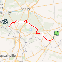
Le plessis belleville -Orry la ville

meillon
User

Length
28 km

Max alt
119 m

Uphill gradient
291 m
Km-Effort
32 km

Min alt
49 m

Downhill gradient
312 m
Boucle
No
Creation date :
2017-08-01 00:00:00.0
Updated on :
2017-08-01 00:00:00.0
6h40
Difficulty : Unknown

FREE GPS app for hiking
 SityTrail
IGN / Geographical institutes
SityTrail Plus
The world is yours!
About
Trail Other activity of 28 km to be discovered at Hauts-de-France, Oise, Le Plessis-Belleville. This trail is proposed by meillon.
Description
le plessis Beleville-orry la ville
Positioning
Country:
France
Region :
Hauts-de-France
Department/Province :
Oise
Municipality :
Le Plessis-Belleville
Location:
Unknown
Start:(Dec)
Start:(UTM)
481375 ; 5438173 (31U) N.
Comments